About Me

My photo
Arizona City, Arizona, United States
We are Barbara and Bill Connor formerly of Meadville, PA. We sold our home in October, 2008 and are now living fulltime in a 39' Titanium 5th wheel RV and loving every minute of it! Back to Arizona for the winter. CLICK ON ANY PHOTO TO ENLARGE.

Monday, May 31, 2010

Brookings and Oregon Coast May 14, 2010


We spent 3 days in Brookings, OR at Whaleshead Beach RV Resort. As you can see, it is a beautifully landscaped park. the rhododendrons were in full bloom while we were there.


Rhododendron bloom.


Here's a sign we're not used to seeing! These warnings are posted along the northern California and Oregon coasts due to the fault located offshore. There was a tsunami in 1964 that caused much damage to several towns along the coast.


We took Ceilidh for a walk on the Whaleshead beach. She found a piece of redwood about 6" long and carried it back to the truck. She loved running on the beach.


One day we took a ride along the Rogue River and found this sign about 35 miles inland. Agness consists of a post office, a general store, and a few houses.


An old school building is now a small museum.


Unusual rock tunnel along the Oregon coast.


What a pleasant cove near Brookings!


This area was covered with Lily of the Valley plants under giant pines.


Sunset on the Oregon coast with a view of "sea stack" rocks .


Tuesday, May 25, 2010

Coastal Drive, Redwoods, Crescent City CA May 12, 2010


We spotted these elk in a field on the Newton Drury Scenic Parkway on our way to the Coastal Drive in Northern California.


One of our destinations was this WW II Radar Station on the California coast. It was designed to protect the U.S. mainland after the bombing of Pearl Harbor. At one time, Japanese subs operated in off shore waters and actually shelled some shipping operations and oil installations off the coast of California and Oregon. To protect from an invasion, the U.S. Army built "farm" buildings. The cinder block structures, complete with shingled roofs and fake windows and dormers house an early warning radar station.


The buildings housed diesel generators, electronic equipment and two 50-caliber anti aircraft machine guns. As the last relatively intact WW II post, Radar Station B 71 was placed on the National Register of Historic Places on April 19, 1978
.


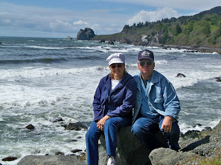
We stopped to admire the beach and Bill snapped this picture of us using his tripod.


This magnificent statue was carved from only one redwood log.


Then on to the Jedediah Smith Redwoods State Park where we took the Highland Hill Road through the park. The road is NOT recommended for motor homes or trailers as there are many sharp turns around these huge trees.


Redwoods often grow from "burls" at the base of the mother tree as you can see here. Whoa! Is that Stanley????


The harbor at Crescent City is very pretty, named for its shape, a crescent. It has been an important port for almost 150 years. The lumber industry shipped much of the redwood, fir, and spruce cut in nearby forests by schooner to poert salong the west coast. Fishing is another important industry.


The Battery Point Lighthouse was first lit in 1856. Since then the structure has weathered many changes including automation in 1953 and a tidal wave that flooded the peninsula in 1964 from the earthquake that struck Alaska. Twenty nine blocks in Crescent City were destroyed at that time. The lighthouse was spared as the tidal wave struck at such an extreme angle the structure was protected.


Accessible only by foot at low tide, Battery Point is now a Maritime Museum. The light is reputed to house a resident ghost, seen by at least six different people, who have heard its sea-booted feet slowly climbing the tower steps during storms.


We found this crab on the beach when we stopped to have a picnic lunch. Notice how dark the sand is here, so different from the beautiful white sands of the Gulf Coast.


Of course there's always someone looking for a handout!


We took this picture while walking on the beach one evening. These rocks, which are all along the California and Oregon coasts are known as "sea stacks." These immense blocks of highly resistant rocks of chert, greenstone, and sandstone are within a matrix of softer, more easily eroded rock called mudstone. The more resistant blocks survive the erosive power of the ocean to form the sea stacks that you see just offshore.
How many times did you see Stanley??

Tuesday, May 18, 2010

Redwoods and Gold Beach, CA May 10, 2010


Eight golden bears have stood ever vigilant since 1925 at various locations around Klamath, CA. This one is at the end of the bridge over the Klamath River.


It didn't take long to find a giant redwood that only exist on a narrow strip of California Coastline which extends 450 miles from the California/Oregon border south to Monterey Bay. Coastal redwoods can soar to more than 370 feet tall!


Even the clover is huge!


We walked the Lady Bird Johnson Grove Nature Trail, a one mile loop that winds through an old-growth redwood forest. Today less than 4 % of old-growth redwood forests remain. At this site in 1969, Presidents Nixon and Johnson joined Governor Reagan in dedicating this 300-acre grove to Lady Bird Johnson and her campaign to preserve America's natural beauty.


How do hollow redwoods survive?? Despite the North coast's wet climate, redwood forests experience occasional wildfires. Countless fires have scorched the base of this redwood. Fires can burn repeatedly through cracks in the bark into the heartwood, but leave the outside growing layers intact. In time, the damaged heartwood decays, leaving behind hollows used as shelter by wildlife.


For a giant of a tree, they have a very small pine cone! Redwoods reproduce by seed and by stump and basal sprouting. Seeds slightly bigger than a pinhead are released from mature cones that ripen in August and September. If a redwood is felled or badly burned, a ring of new trees often sprouts from burls around the trunk's base. These so-called "family groups" are common. Saplings use the parent tree's root system. Redwoods have no tap root; their roots penetrate only 10-13 feet deep but spread out 60 to 80 feet.


Next we took the Coastal Drive, a scenic, partially paved drive 8 miles long that winds through stands of redwood. When we got to Gold Beach we stopped for a picnic lunch.


Gold Beach got its name because of the fine flecks of gold in the sand but it was too expensive to process. It is almost like flour! The sand here is very dark and black because of the volcanic rock in this area.


Chinook RV Park, Klamath, CA May 9, 2010


This was our first view of the California Redwoods as we head north on Rt. 101 on the California coast to our next campground at Klamath, CA.


The campground was almost empty, just a few seasonal folks and a workamper. We had a wonderful site right on the Klamath River which flows 300 miles from Oregon to the Pacific Ocean just 1/4 mile down stream. We ended up staying here for 5 days.


Bill was relaxing, enjoying the view, after a long day's drive. The mouth of the river is just around the bend as it flows into the Pacific.


Brilliant orange California poppies were blooming profusely everywhere. They close up tight about dusk and reopen in the morning.


Periodically, I take a picture and call it "The view from my kitchen window". How relaxing to eat and look out on the river.


Well, well, look who's come up to the Klamath Overlook with us. The mouth of the river is to the left, the California coast, looking south.


We came up to watch the sunset and I liked this picture looking down the coast with the sun shining on the other side of the fence.


The sunset wasn't spectacular like I'd hoped, but it was still serene.


Scotty's Castle, Death Valley, CA May 6, 2010


No visit to Death Valley without seeing "Scotty's Castle" which rises from the dust like a desert mirage. The castle takes its name from Walter Scott, better known as "Death Valley Scotty, " an ex cowboy, prospector, and performer in Buffalo Bill's Wild West Show,


Our tour guide, a National Park Service ranger, dressed in 1939 period costume, told us about Chicago millionaire Albert Johnson, who had been urged by his doctors to spend time in a warm, dry climate. Mrs. Johnson convinced him to build the mansion in Death Valley, one of the harshest deserts in the world.


Named the Death Valley Ranch, it consisted of two areas divided by a courtyard. The area to the left is the main house and to the right is the guest quarters. Scotty's Castle is on the national register of historic place and is a unique museum.


This entrance is inside the courtyard and goes into the living room area of the main house which is open to the ceiling with a balcony on the second floor overlooking the living room and its two fireplaces.


At the time, Scotty told visitors he financed the building himself from the booty from a secret gold mine in Death Valley. The house is furnished as it was in 1939, but not with just any antiques. Everything you see was actually in the castle in 1939, This is the living or what we would call the great room, complete with a fireplace at each end.


The upstairs music room, a favorite of Mrs, Johnson's, had a player piano that was unique in that it has volume built into it. By opening or closing louvers behind the screened area, the music could vary between loud and soft.


The courtyard looks west at the mountains. Although the castle was built in the desert, flowing just below the surface, at more than 200 gallons per minute, is an ancient natural spring. The ingenious use of this abundant water supply provided electricity, indoor plumbing, and an evaporative cooling system-modern conveniences that made the castle quite comfortable for everyone who came to visit.


Albert Johnson didn't seem to mind that the world thought Scotty owned the castle. Sometimes tours were given and if anyone asked who he was, he would reply, "Scotty's banker".
In Albert's own words, "We have been partners for a long time. Scott has a great appetite for money and I like to feed it. He has always repaid me - in laughs."


Rhyolite and Goldwell Open Air Museum, NV May 6, 2010

RHYOLITE GHOST TOWN, NV
Shorty Harris and Ed Cross found gold just outside of Death Valley, CA, in the early 1900s. Because of this discovery, the mining town of Rhyolite was built. In her heyday, Rhyolite had 3 water systems, 3 train lines, over 50 mines, 2 hospitals, 8 doctors, 2 dentists, 19 lodging house, 18 grocery stores, over 50 saloons, and a Catholic and a Presbyterian Church, Rhyolite is the largest ghost town in Death Valley.


The Rhyolite Mercantile. The life span of Rhyolite was about 10 years with some residents holding our for another 4 or 5 years.
Population: 1905-1911 up to 8000 people.
1912-1919 declined to 20 families
Today - 1 other than BLM Caretakers


Bill found this "fixer upper" but decided it wouldn't haul the RV.


Tom Kelly's Bottle House is one of the few still remaining houses made entirely out of bottles. Seems there were plenty of available bottles from the 50 saloons in town!


Thousands of photographers come to Rhyolite every year for the opportunity of a lifetime. This is the remains of the three-story Cook Bank Building, the most photographed ruin in the state of Nevada.


One of the few remaining buildings still in decent shape is the old train depot which later became a casino. It, too, is now deserted.


Just down the road is the Goldwell Open Air Museum which began in 1984 as an artist project of Belgian sculptor Albert Szukalski, best known for his life-size "ghostly" shrouded figures. To make the figures, Szukalski wrapped live models in fabric soaked in wet plaster, posed them, and refined the drapery. When the plaster set, the model was slipped out, leaving the rigid shroud that surrounded them. This is called "THE LAST SUPPER".


Szukalski's figures are found throughout the city in Antwerp, Belgium. This one is called "Ghost Rider". The model, a local man, donated his bicycle to complete the piece.


This eclectic couch was originally created for an artist-in-residence project at the Lied Discovery Children's s Museum in Las Vegas. It was rescued in 2007 and lovingly restored and re-envisioned at Goldwell in 2007.


Sunset from our campsite at the Longstreet RV Park in the Nevada desert was a beautiful vision. Each evening Bill and I would sit and watch the sunset.