About Me

My photo
Arizona City, Arizona, United States
We are Barbara and Bill Connor formerly of Meadville, PA. We sold our home in October, 2008 and are now living fulltime in a 39' Titanium 5th wheel RV and loving every minute of it! Back to Arizona for the winter. CLICK ON ANY PHOTO TO ENLARGE.

Sunday, September 19, 2010

Crater Lake Boat Tour, Sept. 12, 2010


We decided if we were going to take the Boat Tour of Crater Lake we'd better do it today. Soon it will be snowing and the tour boats will be put away for the winter. It was another beautiful day at Crater Lake. The lake was still and the reflections were breathtaking.


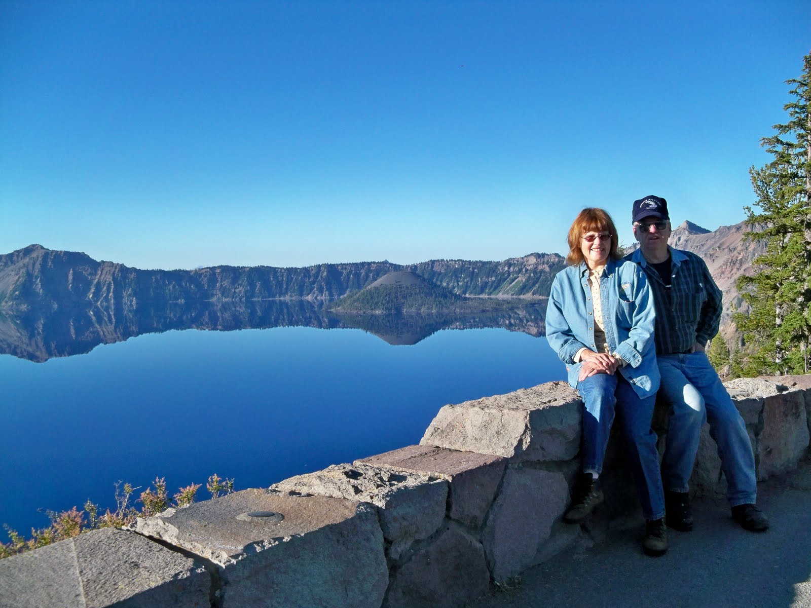
Bill was admiring this reflection of the west rim.


The boat tour requires a 1.1 mile walk down a steep trail on the side of the caldera. It is even steeper going back UP!!
They say 1.1 miles down and 11 miles up. This is the only path that goes down to the lake shore.


Our boat awaits us on this crisp, clear morning.


I didn't get my feet in Crater Lake but I did get my hand in it. It wasn't as cold as I though, being the deepest lake in the U.S. at 1946 feet. But then I was in a shallow area along the bank.


The Phantom Ship Rock formation is even more impressive as you get closer to it. It is 16 stories high and so fragile looking; it's a wonder that it survives the harsh winters here at Crater Lake.


One last view of the Phantom Ship from water level. It really does resemble a pirate ship.


The tour boats are kept in these boat houses on Wizard Island for the winter. Notice the piles of lava rock on the shoreline.


This area on the west side of the caldera is strikingly different from other areas that are covered with trees. Notice the multicolored rock on this hillside.


This 30-foot tree trunk has been floating upright around the lake for many, many years. It travels up to 4 miles a day and you never know where it's going to appear. Evidently the root ball is still attached, keeping it in this position. The lake is 5 miles by 6 miles.


After the boat tour and the hike back UP the caldera we were famished so we enjoyed a delicious lunch at the scenic Crater Lake Lodge overlooking the lake.


We took one last view of the lake from the porch of the lodge. Just beautiful!

Tuesday, September 14, 2010

Bonneville Dam, Aug. 30, 2010


Bonneville Lock and Dam and Fish Hatchery
August 30, 2010
Bill is always interested in power plants so we stopped at the famous Bonneville Lock and Dam located on the Columbia River 40 miles east of Portland, Oregon. Construction began in 1933 by the Army Corp of Engineers and was dedicated by President F.D. Roosevelt in 1937 at a total cost of $88.4 million.


The power house produces over 1 million kilowatts, enough to supply the power needs of nearly 500,000 homes. It takes more than 150 people to operate and maintain the Bonneville Lock and Dam each year.


I found the most interesting part of the tour was the Fish Ladder. Fish ladders planned by Corps engineers, environmental specialists and biologists simulate the waterfalls and pools found in natural streams. These fish ways allow migratory adult fish to continues their migration from the ocean upstream to tributaries of the Columbia and Snake Rivers. The fish jump from one level to the next, much as they would in a natural stream.


Visitors can watch migrating fish move past underwater windows at the visitor center. The underwater lighted windows afford an exciting close-up look at the various fish moving up the ladder. Salmon were passing through when we visited. At each fish way, a worker counts the various species of adult fish moving up the fish ladder. This vital information has been recorded at Bonneville since 1938. Between 700,000 and 1.5 million upstream migrant adult salmon and steelhead, and an estimated 24 to 43 million downstream migrant salmon and steelhead fingerlings pass Bonneville Dam in an average year! Shad, sturgeon, lamprey and other species are also seen.


A visit to the Bonneville Fish Hatchery, located in the same area, was next. The grounds were beautifully landscaped.


There are some huge sturgeon in the Columbia River as seen here. This is the sturgeon viewing area, home of "Herman the Sturgeon." You can see part of the viewing window to the right.


And-along came Herman and another sturgeon. Herman is over 10 feet long, weights over 450 pounds, and is over 70 years old.
We spend an enjoyable and educational afternoon here at the Bonneville Dam-well worth the visit!


Columbia River Gorge, Aug 29-31, 2010

Columbia River Gorge and Mt. Hood Area
Aug. 29, 2010

We hitched up the RV and drove to the Columbia River Gorge area for a few days. Our first stop, after setting up camp at Mt. Hood Village RV Resort was the Columbia River Gorge Discovery Center which interprets the area's geologic, natural and anthropological history.


Bill is standing beside a "dugout" tree trunk that was used as a boat. There were lots of life size exhibits in the museum. The museum told the history of Lewis and Clark and the Oregon Trail.


You know Bill, always looking at trucks or in this case, an old car.


The road to Rowena Crest was quite an engineering feat. There were several miles of these switchback curves on the way to the crest.
Glad we weren't hauling the RV!!


The view from Rowena Crest was stunning looking up (east) the Columbia River.


On the way back to the RV park, we stopped by the Timberline Lodge at Mt. Hood. Mt. Hood can be seen from several different highways in the area but I liked this picture with our flag blowing in the breeze. And, it was COLD up here, about mid 30s and windy. No wonder there's still snow on the mountain.


I didn't get a picture of the outside of the lodge as they were refurbishing it and had scaffolding set up. But the inside was awesome. Huge timbers and fireplaces and this door to an outside porch area were examples of WPA work done in the 1930s. It is a triumph of art and craftsmanship from the soaring lobby to this magnificent door. Notice the huge post to the left of Bill that was at the top of a stairway. Each post on each stairway had a different animal or bird carved on the top.
Tomorrow we'll visit the lower end of the Gorge from Troutdale to Hood River.


Monday, August 16, 2010

Natural Bridge, Union Creek, Oregon, Aug. 15, 2010


How did it form??
It began as a River of Fire when basaltic lava flowed from fissures in the earth's surface and traveled long distances through lava tubes. Lava tubes develop when the upper surface of a basalt flow rapidly cools, causing the outer edges to solidify while the hot inner lava continues to flow underneath. As the molten lava drains out it leaves behind a long hollow tube. Eventually the River of Fire is replaced by a River of Water.


The Rogue River entered a section of a lava tube, becoming a "hidden river" which flows below ground for 200 feet.


In doing so, it created a "natural bridge" that connects the banks of the river. Indians and early settlers used this natural bridge to cross the Rogue River.


The Rogue River emerges from the lava tube outlet after a short underground trip and continues its journey to the Pacific Ocean 184 miles downstream. At peak flow approximately 335,000 gallons of water rush from this outlet at the speed of 6 feet per second. Fed by the melting snow on the slopes of Mt. Mazama (Crater Lake) in the High Cascades, the river's temperature at the Natural Bridge varies seasonally from 32 to 69 degrees F.

Sunday, August 15, 2010

Cascade Scenic Byway and McKenzie Pass, OR 8-1-10


Our first stop on the Cascade Scenic Byway was at Maiden Peak viewpoint. Nearly 7700 years ago Mt. Masama erupted approximately 70 miles southeast of here. The cataclysmic eruption not only formed Crater Lake, it changed this forest forever. Before the eruption only ponderosa pine trees extended down into the basin. Now only lodge pole pine trees can tolerate the harsh living environment on the basin floor.


The distribution of pumice from Mt. Mazama was phenomenal. 30 inches of pumice covered areas into Washington and Idaho. Areas as far north as British Columbia and Alberta, Canada, had as much as 1-5 inches of pumice on the ground. Click on the picture for a closer view of the pumice distribution.


This area also has hills of lava rock stretching for several mile from the Mt. Mazama eruption 70 miles away.


Picturesque Devil's Lake reflects the green of the surrounding pine forest.


From this viewpoint on Hwy 20 outside of Bend, Oregon, you can see Broken Top Mountain to the left and the Three Sisters Mountains in the center and right of the picture.


After going through touristy Sisters, Oregon, we drove the McKenzie Pass Byway, open only in the summer months. Here Bill is standing in the vast lava fields of that area.


The McKenzie Pass Byway follows the path of an 1860s wagon route emerging from the forest to the 5,325-foot summit of McKenzie Pass. Here you are enveloped by lava on all sides.


The Dee Wright Conservatory, a lava rock structure constructed by the Civilian Conservation Corps in 1935, was named for their foreman. From the observatory you can take in six Cascade Peaks on a clear day. In our travels we have seen that the CCC was responsible for building numerous roads, scenic areas and lodges all over the country for future generations to enjoy.


The half-mile Lava River Interpretive Trail is a 30 minutes walk on a paved surface through lava gutters and crevasses. You are on the boundary of two wilderness areas: Mt. Washington to the north and the Three Sisters to the south.


We followed a winding 50-mile mountain road along the McKenzie River back to Hwy 58 and then "home" to Diamond Lake RV Park. Oregon has such gorgeous scenery. We are fortunate to be able to travel around our wonderful country!


Saturday, August 14, 2010

Jerry and Andrea, July 30-31, 2010


We had a great visit with my nephew, Jerry and Andrea. They had stopped to fish on their way from Portland and Jerry fixed fresh trout for our dinner.


We enjoyed the trout, plus salad, hamburgers, and potatoes cooked over the grill.


After dinner we took a sunset ride around Diamond Lake. That's Mt. Thielson in the background. Notice it still has snow on it.


Jerry and Andrea hiked to the summit of Mt. Bailey on Saturday morning while Bill and I worked at the campground. This afternoon, we took them for a ride around the Rim of Crater Lake. Mt. Bailey and Mt. Thielson are in the background and Crater Lake is unbelievably blue, as usual.


Andrea and Jerry are pictured here at the Phantom Ship overlook. They had never been around the East Rim as they had only been here when that road was closed by snow. We all enjoyed the afternoon. Too soon it was time for them to head back to Portland. It was wonderful to have them visit, even for a short time. We will cherish these memories in the years to come.


Thursday, August 12, 2010

High Desert Museum, Bend, OR July 25, 2010


We visited the High Desert Museum in July, just south of Bend, Oregon. It is a huge complex with exhibits both inside and outside.


There is a replica of an 1880s homestead. These cabins were even smaller than our RVs that we live in today, so living in small places isn't all that new! And, they raised a family here.


The cabin was well furnished with everything they needed to survive those difficult times. Outside "pioneers" were doing laundry using a wash board. Another lady was dressed in period clothing and "teaching school' to visiting children showing them how to use a pen and ink well. Two children had a scrub brush and were having fun scrubbing the porch from water in a metal tub! It probably wouldn't have been so much fun if they HAD to do it!


This is a barbed-wire sculpture by Bernie Jestrabel-Hart. The mare and foal are made completely from barbed-wire. The detail was amazing.


We watched a raptor and wildlife show while at the museum. Here, a handler had a hawk perched on her hand. The bird would fly from one handler to another (for a treat), skimming over the heads of those in the audience.


A badger, along with other mammals, made an appearance. Notice the length of his claws!


Tom's sawmill, a working replica of an early sawmill, was a must needed business in the early days of Oregon's lumber industry.


The mill was not operating today as the museum is located in the high desert area of central Oregon and the fire danger was extremely high. Most people don't realize that most of the eastern half of Oregon is considered high desert and very dry. We haven't had rain since early June and everyone is very aware of the destruction from a forest fire.


This is a life-size display in the indoor museum which explained the history of Oregon starting back with the fur trade industry. There were numerous displays depicting the fur trade industry, mining, and of course, the lumber industry which is still so valuable to Oregon's economy today.


A much used stage coach was also on display.


Yep, Bill found another truck... This 1935 forest service fire truck has been restored to immaculate condition.


The Plateau Indians in this area made their teepees from reeds, not animal skins.


The bead work was phenomenal. There were many examples of Indian clothing, head dresses, arrow quivers, etc., all with intricate bead work.


The Indian jewelry was just as beautiful as the bead work. What a sight they must have been when dressed in their ceremonial garments and jewelry!
This was one of the most outstanding museums we have visited and well worth a trip to Bend, Oregon if you are ever in this area. It is very family oriented, having many displays and activities for children.