About Me

My photo
Arizona City, Arizona, United States
We are Barbara and Bill Connor formerly of Meadville, PA. We sold our home in October, 2008 and are now living fulltime in a 39' Titanium 5th wheel RV and loving every minute of it! Back to Arizona for the winter. CLICK ON ANY PHOTO TO ENLARGE.

Tuesday, October 25, 2011

Devil's Tower, Wyoming, Aug 12-13, 2011

DEVIL'S TOWER, WYOMING


After miles of open range, Devil's Tower rises out of the earth to a height of 1267 feet above the
Belle Fourche River. Even after extensive studies, scientists are still debating the origin of Devil's Tower.


One of the most striking features of the Monument is its polygonal columns. Most of the columns are 5-sided although some are 4- or 6-sided. The largest columns measure 15-20 feet at their base and gradually taper upward to about 10 feet at their summit. There is a 1.3 mile trail around the base which made a pretty walk one afternoon.


About 1500 climbers will make it to the peak each year. The summit is about the same as the surrounding except you can see 5 states!.. The summit is actually domed and is covered with prairie grasses, big native sage, prickly pear cactus, current and gooseberry bushes, thanks to prairie falcons and vultures that drop seeds up there. A few rattlesnakes, pack rats, and red squirrels have also found their way up the rock.

Can you see the climber??


Near our campground is a prairie dog town where we spent part of a morning watching their antics.


The tower is sacred to the American Indians in the area. According to the Kiowa legend, seven sisters watched in horror as their brother was turned into a bear. The sisters run from him to the stump of a large tree, which beckons them to climb on. When they do, the stump rises up into the sky and the bear, unable to climb up the stump to reach the sisters, scores it with its claws. The sisters are then raised into the sky becoming the seven stars of the big Dipper.


East Glacier National Park and Little Bighorn, Montana, Aug 7 -9, 2011


Once we crossed the border it was just a short drive to East Glacier National Park. While the scenery was beautiful, this is the absolute worse run park we have ever visited. In the spring in West Glacier the park hired an outside contractor to chip/shred all the small trees that had fallen over winter and let them take the larger trees. (In Canada at the Provencal Parks they have shelters loaded with FREE firewood,)


Going To The Sun Road


There is a free shuttle bus to take you from East to West Glacier and there is awesome scenery, BUT, we were at the shuttle pick up area 10 minutes before it left and there was no room. So we waited an HOUR (with 3 shuttle buses sitting empty nearby) for the next shuttle. They pick up so many people that as many as 10-15 had to stand. (That doesn't seem very safe on a bus on a winding, hilly road.) There are also 2 or 3 places that you had to change buses and of course you had to wait for the next bus to come. The ride is advertised as 2 hours so I figured 4 hours total plus a little time to eat lunch at East Glacier. It was after 5 pm before we got back!!


The vastness of Montana comes to life as you drive past hundreds of thousands of acres of wheat fields as far as the eye can see.


Next stop was Little Bighorn Battlefield near Crow Agency, Montana. We listened to the account of the events leading up to the battle by a park ranger that was also a local Sioux Indian. He painted a vivid picture of battle on June 25, 1876, in which General George Armstrong Custer met his demise. While the battle lasted 2 days, Custer's famous last stand lasted only about 20 minutes!


There is also a National Cemetery located near the battlefield with row after row of markers honoring our fallen heros.


Continuing across Montana revealed beautiful rolling plains and far distant mountains. Montana is truly "big sky country." What a beautiful country we have- God Bless America!

Alberta, Canada August 3 to Aug 6, 2011


Down through Alberta we passed hundreds of acres of brilliant yellow canola fields, one of their major agricultural crops.


We spent the night in Wetaskiwin so we could visit the Reynolds Alberta Transportation, Aviation, Agriculture and Industry Museum. It is a wonderful informative collection of all types of transportation. The layout is of old store fronts with the old machinery and autos parked along the "street".


I thought this restored 1928 Dusenberg was stunning. Doesn't it make you think of the "Roaring 20s"?


Bill is standing beside this huge tractor which starts on gasoline then converts to kerosene as a cheaper fuel.


The next day we visited the Heritage Park Historical Village in Calgary. It is the Canada's largest living history museum. We arrived around 9:30 am when it opened and it was suddenly almost 5 pm when we had to leave. We could have spent another day there as there is so much to see and do.


Gasoline Alley boasts one of the largest public collections of antique vehicles and oil and gas related artifacts in the world. This interactive exhibit brings the 1930s, 40s, and 50s to live in an unforgettable way. The gentleman here, dressed in period attire, told us about this first tow truck that was converted from a Cadillac truck.


Inside one of the homes this Bobbin lace weaving was on display. The lace being made was so pretty but it sure looks confusing as to how it is woven. Sadly, this will soon be a lost art.


Throughout the village were original houses moved here from Calgary. This was a school house with a playground beside it. Inside you could listen to the "teacher" giving the days lessons. Outside on the streets were old trucks and horse drawn vehicles.


Another picture inside gasoline alley was of this grocery delivery truck. Everything was immaculately restored. The park also has an operating steam engine that circles the historical village on 1 mile of track. Over 115 exhibits include a paddle wheeler, an old fashioned park with ferris wheel, carousel and other rides, ranch house, post office, train station, an Indian encampment and a fort. There is so much to see and do here. I highly recommend it for anyone visiting the Calgary area. You won't regret it!

Friday, October 7, 2011

Back to the "Mile 0" July 29-Aug 2


BACK TO THE LOWER 48


Finally it's time to head "outside" to the "Lower 48". Ceilidh is glad to be going "home" but little does she realize that she has another 2 months until we are back in Texas for the winter.


We are not the only ones heading south as we follow a long line of RVs through the Yukon Territory on the Alcan Highway. I'm sure all of us are saying the same thing: "What a wonderful summer! Alaska is a magical place."


Early one morning after camping along Kluane Lake in the Yukon Territory we saw this grizzly bear loping along the lake.


Again we drive along miles and miles of Aspen and Spruce trees. The snow on the mountains is gone for now but soon winter will be upon them again. The aspen tree leaves are a silvery color due to a leaf minor disease that eats the chlorophyll out of the leaves.


Our last night on the Alcan was spent at lovely Summit Lake on Stone Mountain. What a view! I love these beautiful mountains and never tire of gazing at them.


We spotted this moose in the fireweed along the roadside in the Yukon Territory. What a magnificant animal. Many people fear them more than the bears as they are very protective of their "space".


Just outside of Dawson Creek you could still see evidence of pine beatle destruction. It is so sad to see the beautiful forests being slowly destroyed. But that is the cycle of nature.

What an awesome, unforgetable summer. I am truly sad that it is over. Maybe someday we will return to the "last frontier" as there are still many places I would like to visit.


A FEW STATISTICS AND "BEST" THINGS WE SAW AND DID:


Total Miles from Dawson Creek back to Dawson Creek: 6038

73 nights of camping averaged: $18.69 per night

Camping and fuel costs: $3480.00

Favorite town: Me, Seward on the Kenai Peninsula

Bill, Palmer

Best eagle viewing: Haines

Best campground: Palmer

Worst campground: Wasilla Municiple (we didn't stay)

Best sunset: Ninilcik over the Cook Inlet

Best wildlife experience: Bear at the rv in Williwaw Campground in Portage

Prettiest flowers: Fireweed

Most picturesque town: Seward and Seldovia

Best cinnamon rolls: Bayside Bakery on the Homer Spit

Most unusual store: Save-U-More, Homer. They actually sell hay in the grocery store AND the have the best ice cream cones for 99 cents!

Best cruise: They were all awesome in their own respect. Fast Ferry to from Haines to Juneau; Major Marine buffet cruise from Seward to Aialik Glacier, and Stan Stephenson's cruise from Valdez to the Columbia Glacier. Each was special in its own way.

Best fish: Salmon patties from Peter Pan Cannery in Valdez

Most educational tour: Bus to the Arctic Circle

Best museum: Wow, hard to say: University of Alaska museum at Fairbanks, Native Alaska Heritage Museum in Anchorage, Maxine and Jessie Whitney Museum in Valdez

Most interesting: '64 earthquake, Alaska pipeline, permafrost.....

Most beautiful: Denali National Park (It's like potato chips-it's hard to pick just one!)

Thursday, July 28, 2011

Valdez, Alaska, July 25-28, 2011


Valdez, AK, July 25-28, 2011


We spent 4 days in Valdez and had a very scenic campsite right on the Valdez Bay across from the town. Valdez is famous for a couple of things-the devastation from the '64 earthquake whose epicenter was just 40 miles away, the oil spill of the Exxon Valdez and....


...the terminus of the 799 mile long Alaska Pipeline. About 800,000 barrels of oil per day move through the pipeline at about 3 mph. Transport time from Prudhoe Bay is 12 days. The Valdez Marine Terminal covers a total area of 1,000 acres with all facilities except berths built to bedrock at elevations ranging between 15 and 660 feet. Valdez has 18 storage tanks with a capacity of more than 500,000 barrels per tank= 9.18 million barrels of total storage.


The first evening we were here there was a small brown (grizzly) bear "fishing" along the shoreline. He didn't seem to mind his picture being taken as he was intent on finding supper.


This huge Indian Sculpture adorns the Community College Campus in Valdez. Hungarian-born sculptor, Peter Toth had undertaken a vow to carve an Indian sculpture in each of the 50 states. The monument he carved in Valdez, was his 40th tribute to the plight of the American Indian. He refused to take any payment for any of the monuments, as they are his gift to the American people. The Louisiana Pulp Company donated the wood.


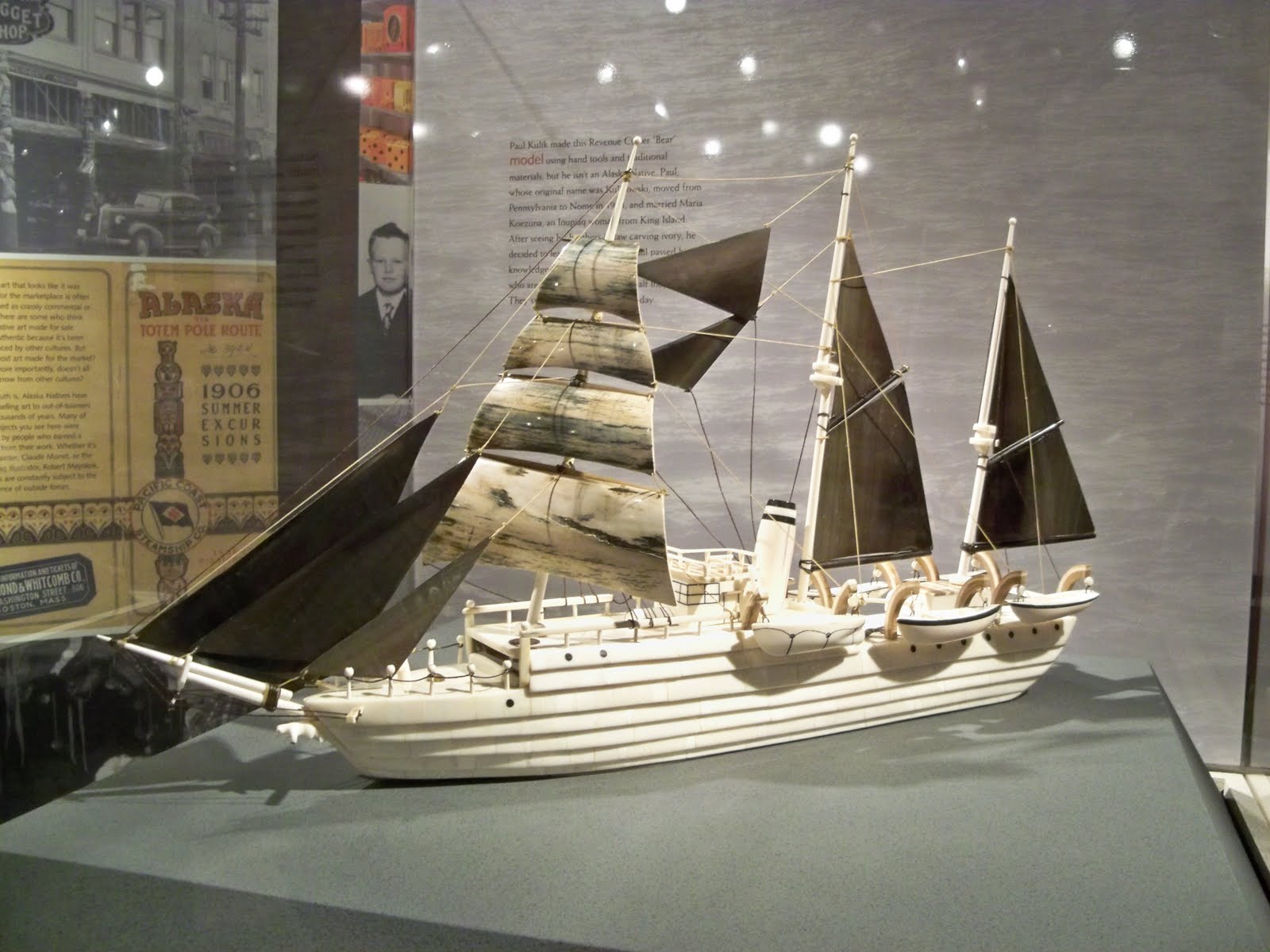
Also on campus is the Maxine and Jesse Whitney Museum, one of the world's largest collections of Native Art, artifacts, and mounts. Maxine once owned a gift shop in Fairbanks and went out in the bush to buy directly from the natives. She donated her entire collection to the college and they built a special building to house the museum. This ship was carved from ivory. What talent the Native Alaskans have to be able to create such beauty.


This moose mount had an antler spread of 68 inches and weighed around 1500 pounds! No wonder they are so dangerous. They are more feared than the bears in Alaska.


I took this picture behind the rv looking across the bay early one morning while the clouds were still sitting on the mountains. The fireweed, which indicates that summer is half over, is everywhere. It is called fireweed because it is the first vegetation to grow after a forest fire. God takes away beauty and gives back beauty.


We took a wildlife / glacier cruise to Columbia Glacier, one of only 2 tidewater glaciers, meaning the glacier goes down into the water. This glacier once covered the whole area, but now is actually 3 smaller glaciers. The glaciers on the left are 1 to 1 1/2 miles wide and the one on the right is 2 miles wide. It extends 35 miles up the mountain, sits 200 - 300 feet out of the water and 800 feet below the water. It calves 10-14 tons of ice daily as evident in the water. We were fortunate to be able to get within 2 miles of the glacier as most trips stop about 12 miles out due to ice being caught on the moraine and causing an ice jam.


Here several seals were enjoying the sun on an "ice raft" so to speak!


One more picture of the Pipeline terminus also shows a glacier high on the mountain. Valdez is surrounded by glacier covered mountains. A tanker is being loaded and will be escorted some 70 miles through Prince William Sound into the Gulf of Alaska, hopefully to prevent any further oil spills.


The Alaska part of our vacation is almost over as we head out to Tok and the Alaska Highway back to the "outside" or lower 48. It's been a very educational and beautiful trip. Alaska is truly the "Last Frontier".

Thursday, July 21, 2011

Kenai Peninsula-Portage and Whittier, July 17-19, 2011

Portage and Whittier, AK July 17-19


Our next stop was at Williwaw NFS Campground in Portage Valley. The town of Portage was destroyed and never rebuilt after the 1964 earthquake. As you enter the campground you have a marvelous view of Middle Glacier from the Columbia Icefields. In the foreground the fireweed is starting into bloom. The flowers bloom from the bottom to the top. I don't know why they call it a weed: it is absolutely beautiful and blooming in profusions along the highways.


The National Forest Service parks in Alaska are awesome. This one has spacious, paved sites and a wonderful view of the mountains. With my Access Pass, we only pay $9 a night to camp here.


No, Bill wasn't walking around in his bare feet, but these are bear feet! Sitting in the RV around 9:30 am we heard something hitting the side of it and when I looked out, there was a black bear. He had his feet on the side and was trying to look in! I went to grab the camera, but Bill had left it in the truck! The first night we camped here a woman left the door to her motor home open and a bear started to go in-she screamed and a fellow camper scared it off by firing a gun into the air. The next night the bear wasn't so lucky. He refused to leave a campsite and was threatening a camper and the man shot and killed him. But evidently there is still at least one more around trying to break into campers. We have finally seen a bear in a campground-up close and personal!


Portage Lake has a really nice visitors center with a film and a museum. Portage Lake has 3 glaciers surrounding it: Burns, Portage, and Byron Glaciers.


The only way to Whittier (other than plane or boat) is through this 2.5 mile long Anderson Memorial Tunnel. It is the only tunnel in the world that is shared with a railroad. You actually drove over the railroad tracks when you go through it.


Whittier, another little coastal town that was started as an Army base during WW II, is now a fishing and tourist town. The harbor, surrounded by mountains and glaciers, is similar to the other harbor towns we have visited on the Kenai Peninsula. Fishing boats and cruise ships are evident. We had lunch at the Lazy Otter Cafe overlooking the harbor.


The Begich Building, left over from the Army base, now houses about 1/2 of the population of Whittier which is about 250 people total. The harbor, train tracks, fish processing plants, and of course a few little gift shops and cafes make up the town. Notice the waterfall behind the building coming down from the icefield far above it.

We have spent 3 weeks on the Kenai Peninsula and have had a good experience here. It is truly beautiful and the place to be if you like to fish!


Kenai Peninsula, Seward AK July 10-16, 2011

Cooper Landing and Seward, July 10-16
On our way from Homer to Seward we stopped for a day at Cooper Landing and took a raft trip on the Kenai River. Our guide, Brad, is from Cannonsburg, PA, just south of Pittsburgh where Bill was born. He is a middle school teacher in Anchorage in the winter and fishing/raft guide in the summer. He had many interesting stories to tell of his adventures in Alaska including being "bluff charged" by a bear twice. He said he would rather face a bear than a moose, though. He came very close to shooting a moose that was threatening him and his dogs. They are very aggressive when you are in "their space"!


This is the Resurrection Bay campground we stayed in while in Seward. Our RV is just right of center with the bay on the south side and the mountains to the north.


We drove a short distance to Exit Glacier and were able to hike to the face of the glacier. The braided river is a result of glacial melt. Braided rivers are so called because they are continually changing their course in the gravel river base and form many channels.


We have been told many times that there are no rabbits in Alaska, only snowshoe hares. But, Seward does have many domestic rabbits all over town! These two were playing one evening as I was walking Ceilidh. She sure wanted to play with them! I guess the Seward rabbits are equivilant to the Key West chickens. This has become my favorite Alaskan town.


Mount Marathon, see from our RV site, is the scene of an annual 4th of July race. Runners ascend and descend the 3200 ft. mountain, the winner in less than 45 minutes. Coming out of the treeline towards the top left you can see the trail they use. This little town of 2600 swells to 25,000 on July 4th for this race!


Downtown Seward has its collection of colorful little shops and cafes and houses Alaska's only aquarium, the Alaska Sealife Center. It is also known as the Gateway to Kenai Fjords National Park and was voted an All American City for the third time in 2005. There are 7 streets in town running parallel with the bay and the mountains and Ceilidh and I would walk them twice every day.


Tour boats go out several times a day to cruise Resurrection Bay or out further to the Gulf of Alaska and the Kenai Fjords National Park. We took a 7+ hour cruise. It was a beautiful, sunny day and we enjoyed standing outside, viewing the many glaciers and mountains that surround Resurrection Bay.


Included in the cruise was an all-you-can-eat buffet with mixed greens and mandarin orange salad, rice pilaf, salmon and prime rib. It was lovely eating dinner and watching the scenery. About an hour before we returned to the harbor, we enjoyed a dessert buffet: cheesecake, frosted brownies, carrot cake, tropical fruit and jello. Yummmmm.


One of our destinations was the Aialik Glacier coming down from the Harding Icefield, which is the largest icefield entirely within the US. We were fortunate to be able to watch it "calve" where a chunk of it breaks off. There were strong northerly winds as you an see from my hair and jacket puffed out with air!


Back at the campground Bill and I would sit and enjoy the beautiful weather. On this day it was 75 degrees, the hottest in all of Alaska! Cruise ships were usually in the harbor and the fishing boats were constantly going in and out. Sometimes a fishing boat would dump fish carcass in the water and as they washed ashore the gulls would have a feast. That is, until the eagles came and helped themselves!


What a lovely town, but all good things must come to an end and we must head to another destination.