About Me

My photo
Arizona City, Arizona, United States
We are Barbara and Bill Connor formerly of Meadville, PA. We sold our home in October, 2008 and are now living fulltime in a 39' Titanium 5th wheel RV and loving every minute of it! Back to Arizona for the winter. CLICK ON ANY PHOTO TO ENLARGE.

Thursday, October 22, 2009

White Sands National Monument, Oct. 14, 2009


At the northern end of the Chihuahua Desert lies a mountain-ringed valley, the Tularosa Basin. Rising from the heart of this basin is one of the world's great natural wonders, the glistening White Sands of New Mexico.


Great wave-like dunes of gypsum sand have engulfed 275 square miles of desert here and created the largest gypsum dune field in the world. The dunes, brilliant and white, are ever changing. They grow, crest, then slump but always advance.


The common mineral gypsum is rarely found as sand because it is soluble in water. Rain and snow in the mountains dissolve gypsum from the rocks and carry it into the Tularosa Basin. Rivers would usually carry dissolved gypsum to the sea, but no river drains the Tularosa Basin. The water, with the gypsum and other sediments is trapped in the basin.


One of the basin's lowest points is the large playa, Lake Lucero. This dry lake bed occasionally fills with water that then evaporates and deposits dissolved gypsum on the surface. Strong winds blowing across the playa pick up gypsum particles and carry them downwind. As sand grains accumulate as a dune, they bounce up the gentle windward slope and ripple its surface. At a dune's steep leading edge, sand builds up until gravity pulls it down the slip face, moving the dune forward. These low dunes can move 30 feet a year.


They have these neat picnic shelters to protect you from the winds. You can see how high the dune is in the background by comparing it with the motor home parked there. You can rent "saucer sleds" at the visitor center and slide down the dunes just like down a snow covered hill.


The eroding mountains have now filled the Tularosa Basin 2000 feet deep with sediments, including the gypsum that forms its white sands. Here they have to keep the road plowed to keep off the encroaching sands. Looks like winter in Pennsylvania!

What an amazing world in which we live.


White Sands Missile Range, NM, Oct. 14, 2009


White Sands Missile Range

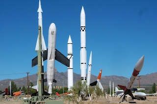
On our way to White Sands National Monument we stopped at the Museum and Missile Park just west of Las Cruces on Fort Bliss, New Mexico.


Established in 1945, White Sands Missile Range is America's largest overland military test range. At White Sands the world entered the Atomic Age when the first atomic bomb was tested at Trinity Site on July 16, 1945.


In 1949, the world entered the Space Age from White Sands, when Bumper, an early two-stage rocket roared beyond the earth's atmosphere. In 1950, bumper went on to become the first missile launched from Cape Canaveral.


At the close of WWII, White Sands proving Ground was established to test the emerging rocket technology. Since 1945 the missile range has conducted more than 42,000 missile and rocket firings. The range also conducts purely scientific research. Rocket payloads from NASA are regularly launched to collect information about the sun and stars or conduct microgravity experiments.


Today, White Sands continues to test the most advanced technologies. Many missiles like the THAAD don't have explosive warheads anymore-they must actually strike the target to destroy it. The military shares the range with a huge assortment of plants and animals in almost pristine conditions. Recently, wildlife biologists studied mountain lions found in the White Sand mountains. Other scientists are currently conducting research on one of the world's largest herds of African oryx which freely roams the missile range.

Gila Cliff Dwellings, New Mexico, Oct. 13, 2009


After a brief visit to Silver City, we headed north on Route 15, through the Gila (pronounced Heela) National Forest and to Gila Cliff Dwellings.


Tour books recommend that vehicles pulling trailers longer than 20 feet to use a different route. Route 15 is only 44 miles but takes a good 2 hours to get to the Cliff Dwellings. We enjoyed the ride through the national forest.


We found this rest area to stop and have lunch. You can see the beautiful mountain view.


More questions than answers surround the story of people who built structures in natural caves of Cliff Dweller Canyon. Archeological evidence suggests that many different groups of people have inhabited this area over thousands of years. The people who built the cliff dwellings were part of the Mogollon culture.


Another famous group of people who occupied the area were the Apache Indians who migrated to the upper Gila river about 1500. Legendary leader Geronimo was born near the Gila river headwaters in the early 1820s as Mexico challenged Apache control of the area. This monument to Geronimo says "I was born by the headwaters of the Gila. Geronimo, Chiricahua Apache Chief. 1829-1909".


The Mogollon found abundant game and fertile soil in the Gila River valley for both native vegetation and their crops of corn, beans, and squash. Breaking the tradition, the Tularosa Mogollon build inside the caves of Cliff Dweller Canyon with rock, mortar, and timbers from trees cut between 1276 and 1287. But by 1300 the Gila Cliff Dwellers had moved on. These caves were much larger than the ones at Bandelier.


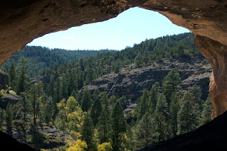
Approximately 40 rooms were built inside several natural caves in Cliff Dweller Canyon. This picture was taken from inside one of the caves-what a view of this rugged, wild area.


I spotted this cactus in bloom along the trail. The leaf was about 12 inches long.


Here's a look at the cliff dwellings from across the valley. They faced south to capture the heat in the winter when the sun was lower in the sky and were kept cooler in the summer when the sun was higher and didn't shine directly into the openings.


We took a different route back to the campground and found this wonderful view out across the mountains.


Santa Rita Copper Mine, New Mexico Oct. ,2009


SANTA RITA COPPER MINE


Fifteen miles east of Silver City and located in Santa Rita is an open pit copper mine. The huge pit, 1.7 miles across and 1000 feet deep, has produced mountains of ore since the discovery of the deposits in 1800. Known as the Chino Mine, it is one of the largest operations of its type in the United States. Kit Carson reportedly worked here for awhile in the early days.


Chino Mines provides an observation deck to view the area. They suspended mining and milling activities in December, 2008, but will continue reclamation activities and copper production from it SX-EW plant.


Albuquerque Relatives, Oct 10, 2009


One of our primary reasons for visiting Albuquerque was to visit with Bill's Aunt Ernie. At 93 years young she has an extraordinary memory and so many wonderful stories to tell. She still lives in her own home by herself and gets around amazing well.


Joanie and Ben had a delicious ham dinner for us along with another cousin, Bill and wife Gail. Left to right Bill, Aunt Ernie, Gail, Joanie, Ben, and my Bill.


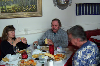
Sunday found us having lunch at this 300 year old former hotel in "Old Town" called La Placita on the Plaza. Yes, that's a tree in the middle of this dining room.


Here's a better picture of us enjoying an authentic New Mexican meal.


Balloons, Sandia Peak, Albuquerque, NM Oct. 10, 2009


Commanding the wide valley between the Sandia Mountains and the sweeping plateau country paralleling the Rio Grande, Albuquerque is New Mexico's largest city. At an elevation of over 4900 feet, it's elevation makes it one of the highest metropolitan areas in the United States.


We parked the RV beside Bill's cousin Ben's house in Albuquerque. That's Joanie, Ben's wife. They were just wonderful to us. Made us feel right at home. We visited Old Town on Friday, a quaint area of of flat-roofed, adobe-style buildings.


Saturday morning Ben and Joanie took us to see the famous Albuquerque Balloon Fiesta. There were hundreds of balloons over Albuquerque. I liked the cow. You can see how big is was compared to the rest of the balloons.


This guy was pretty cool too. Local wind and weather conditions create what is known as the "Albuquerque Box", an atmospheric effect occurring during the fall season and enabling pilots to change direction by varying their altitude, making precision flying possible.


For this reason, hot-air balloonists come from all over the world to fly here, especially during the 9-day Albuquerque International Balloon Fiesta, held during the first half of October.


The most dramatic fiesta events are the mass ascensions during which some 700 colorful craft take to the sky all at once.


After all the balloons launched we started the chase. This one was right over head.


Next was a beautiful 6-mile drive through the Cibola National Forest to Sandia Peak. The leaves were gorgeous. At 10,278 feet, Sandia Peak is a popular recreation spot. We picked a great time to visit to New Mexico!


From Sandia Peak you can see up to 80 miles in the distance. This shot is overlooking Albuquerque.

Wednesday, October 21, 2009

Bandelier National Monument, Oct. 8, 2009


Just 50 miles northwest of Santa Fe is the 50-square mile Bandelier National Monument on the Pajarito Plateau in the rugged canyon and mesa country of northern New Mexico. Remnants of an Ancestral Puebloan community established 7 or 8 centuries ago include pueblo and cliff dwellings.


Huge ash flows from the Valles Caldera eroded into the rugged canyon and mesa terrain that typifies the Bandelier area.


Ha! I got here first! There were no trails into the Frijoles Canyon until the mid-1930s when the Civilian Conservation Corps (CCC) built one, along with trails, the visitor center, and a lodge.
Bandelier is unusual in that there are only three miles of public road within it 33,750 acres, but there are 70 miles of trails.


Ladders provide access to several cave dwellings along the Main Loop Trail. Stone homes once stood in front of many of these caves. Ancestral Pueblo people in and around Bandelier, like Pueblo ancestors elsewhere, were farmers who grew maize (corn), beans, and squash. They supplemented their diet with native plants and by hunting deer, rabbits, and other mammals and birds. Cotton was cultivated and woven into garments. The people made winter blankets ingeniously woven of yucca-fiber string twisted with turkey feathers or strips of rabbit skin.


Archeological surveys show at least 3,000 sites in Bandelier, but not all were inhabited at the same time. For generations these people lived in small, scattered settlements of perhaps one or two families. As the population grew, people began coming together in larger groups, and, by the mid-1200s, villages often included as many as 40 rooms.


The mountains, being of ash from the lava flows, are easily eroded by the wind and rain, thus producing a "swiss cheese" effect. This is a natural erosion. Kinda scary, huh??


From inside of one of the cave dwellings, you can see the remains of the village of Tyuonyi in Frijoles Canyon. The height of its development was in the 1400s. By the mid 1500s the people who lived there had moved on, settling into new homes in villages along the Rio Grande River.


This is a good picture of the cliff dwellings. Notice the double row of "holes" in the rock. These indicate a two story house, the holes from vegas or beams that once supported the floor/roof .


Rio Grande Gorge, New Mexico, Oct. 8, 2009


Just north and west of Taos is one of the loftiest highway bridges in the nation. The three span, continuous-thruss bridge crosses Rio Grande Gorge some 650 feet above the river.


It is amazing-you drive several miles and all you see is the huge Rio Grande Valley. Flat as far as the eye can see. Then suddenly the bridge and the gorge cut a swath down through the valley.


Bill is standing in the middle of the bridge on an observation deck. You can see the Rio Grande River far, far below.


The view is quite breathtaking. I could walk out on the bridge but couldn't look down until I stopped walking! And everything surrounding the gorge for miles and miles is absolutely flat.


Friday, October 16, 2009

Taos Pueblo, Oct. 8, 2009


On the way from Santa Fe to Taos, we passed the mighty Rio Grande River. It isn't very impressive here but it sure is pretty!


Taos Pueblo is considered the oldest continuously inhabited community in the USA. Their native language, Tiwa, is unwritten, unrecorded and will remain so. The details of their traditional values are guarded as sacred and are not divulged. Past oppressions upon their culture have required them to keep the details unspoken.


The San Geronimo Church, built in 1850, is one of the youngest buildings in the village. It is an extraordinary example of the architectural achievements of the natives. Today about 3/4 of the population shares in some of the Catholic practices, while the native rituals perseveres 100% in daily life. Native religion is verbally passed down from generation to generation.


Red Willow Creek is named after the willows that grow along the banks. It is the life source and sole source of drinking water for the natives of Taos Pueblo. Water is carried to the home by pottery and/or water pails. It divides the Pueblo in the "North Side" and the "South Side". High above in the Sangre de Cristo Mountains, the crystal clear water flows from a sacred source known as Blue Lake. Blue Lake and surrounding wilderness area are sacred sites, therefore non-tribal members are not allowed to trek into these areas.

This is the South House or Hlaukkwima of the Pueblo with the Sangre de Cristo Mountains in the background. These structures are believed to be well over 1000 years old. The buildings are made entirely of adobe which is earth, straw, and water mixed and poured into forms. After the bricks are sun-dried, they are stacked and bonded together with the same adobe mixture. The walls are frequently several feet thick and the interiors are coated with washes of white earth to keep the room bright and clean.


The North House or Hlaauma is of the same construction and looks much like it did when the Conquistadors first arrived. The exception are the addition of doorways. At one time, the only entryway into the homes was by ladder through an opening in the rooftops. The wooden structures in front are for drying meat, vegetables, and herbs.


The buildings are actually many individual homes built side by side and in layers with common walls and no connecting doorways.


There were numerous dogs in the pueblo and they obviously weren't concerned with us.


A very important part of every household was the horno. Horno is a Spanish word to describe the outdoor adobe oven that is used mostly to bake bread and pastries by the women of the Pueblo. A cedar fire is built to heat the oven, then the ash is removed. The loaves/pastries are placed inside to bake. The horno is also perfect for baking large portions of wild game and vegetables.


The cemetery is where the original San Geronimo Church once stood. built around 1619 by the Spanish priests with Indian labor the people of Taos Pueblo were forced into Catholicism and slavery in order to become "civilized". This is what eventually led to the Pueblo revolt of 1680. In the success of the revolt, the Pueblo people of New Mexico lived freely until the reconquest by the Spanish in the 1700s.