Sunday, Sept. 20 we decided to go see the Great Sand Dunes National Park and Preserve. On the way we passed Mt. Blanco. Notice how sparse and desolate the land looks here in the San Luis Valley.
The aspen are just starting to change colors on the mountain sides. It's as if God had dabbled the hills with gold and yellow paint as the colors are splashed here and there.

Another view of the mountains and dunes with the visitor's center to the right. Wind and water are the primary movers of the sand. Streams, melting snow, and flash floods brought bits of rock out of the mountains to the valley floor. Southwesterly winds then began the slow process of bouncing the grains of sand toward the low curve of the Sangre de Cristo Mountains. There they piled up at the base of the mountains or dropped into creeks to be washed back out toward the valley floor.

We ate a picnic lunch here before going out onto the dunes. Notice how high the dunes are compared to the RV in the parking lot. Why are they so tall?? Huge quantities of sand are carried downstream by Medano Creek, then redeposited by winds on the eastern slope of the dunefield, accounting for the high dunes in that area. Less common but stronger winds blow from the northeaserlies that blast through the passes and pile the dunes back upon themselves.

Most of the sand originated in the San Juan Mountains, over 65 miles to the west. The larger, rougher grains and the pebbles originate in the nearby Sangre de Cristo Mountains.

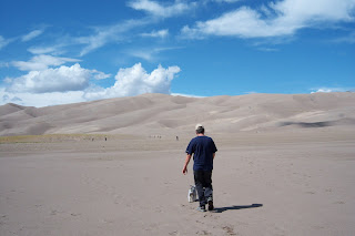
It is recommended that you walk the dunes early in the morning or later in the afternoon as the sand gets very hot, over 140 degrees on summer afternoons. Those little black specks in the distance are fellow hikers.
Notice the crisp edges of the dunes, which are ever changing in shape. They are the tallest dunes in North America and cover more than 330 square miles!


No comments:
Post a Comment